__________CIRCULAR ROUTE OF COTERA ALTA________ |
This is a set of routes, as others described here have a strong vocation forest, resulting in multiple combinations ranging from simple walks along a paved trail to travel throughout the valley head. Here we describe the widest, although the sketches try to reflect all possible combinations. The running through the head of the valley is a circular route which, starting in the vicinity of San Miguel de Aguayo is promoted first by an excellent track until you reach a hill where is there another that runs along the top of the impressive mass forest that dominates the valley head and serves as a divider between the Ebro basin and the Atlantic. Hours .....: 3 to 4 hours. Dificultad..:Paseo (to leave the forest) - Medium / High (entire route). Period .......: All year (In winter there may be snow on the top) |
|
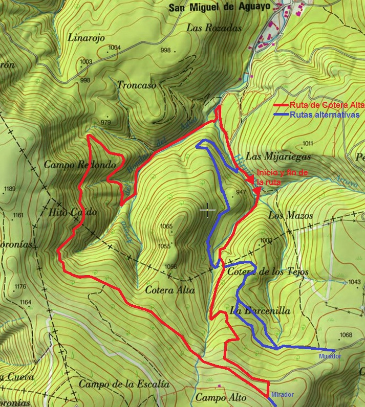
_____________________________LOCATION MAP____________________________ |
|
|
|
______________________________DETAILED DESCRIPTION______________________________ |
|
Getting to San Miguel de Aguayo and continue along the road towards the head of the valley for approximately 1.100m, ignoring all branches appear until the track is divided into two. Leave the car at that point and pick the right one, the one that goes into the forest. |
|
Continue along the track, which can be paved at some point, amounting surrounded by a thick beech tale, leaving some meadows to the right, and ignoring any branch later, first to the right and then back to the left, until after a long time and sometimes certain gap down through the southern edge of the forest, the surrounding brañas. The road at this point turns in an easterly direction, and remains a hillside without promotion. Parallel to it but above 50m (right) runs the track by which we must follow, but pinchudos gorse and prevent us from seeing her walk toward her, so we must continue for 300m until reaching a meadow. Here we ascend towards the South (turn right) to short out the above track (not to be confused with a caminejo that between the two, is a good track, not a road). Note that this is the only point that will provide orientation problems, so we must ensure that we are well on track. |
|
Also mention here that if the day is sunny, at this point we can proceed to the watershed to watch the spectacle of the Ebro reservoir from the North. |
|
Having identified the track we take the ramp on the left, to the west (West), and walk along it until a fork. The right one leads to cotera Alta, a mound that is ahead of the main line, and just a few hundred meters into the forest. The other (left) is the one that continues and we take you through the top of the head of the valley, going back into the forest. Then begins a descent with some muddy floor until, after several revolts and ignore any fork that does not fall to reach the road we had to leave San Miguel de Aguayo, at that point we should turn it clockwise to get back to the car. |
|
|
|
______________________ ROUTE MAP_______________________ |
 |
